Curiosity rolls into a sea of 4-8-centimeter polygons on Mars
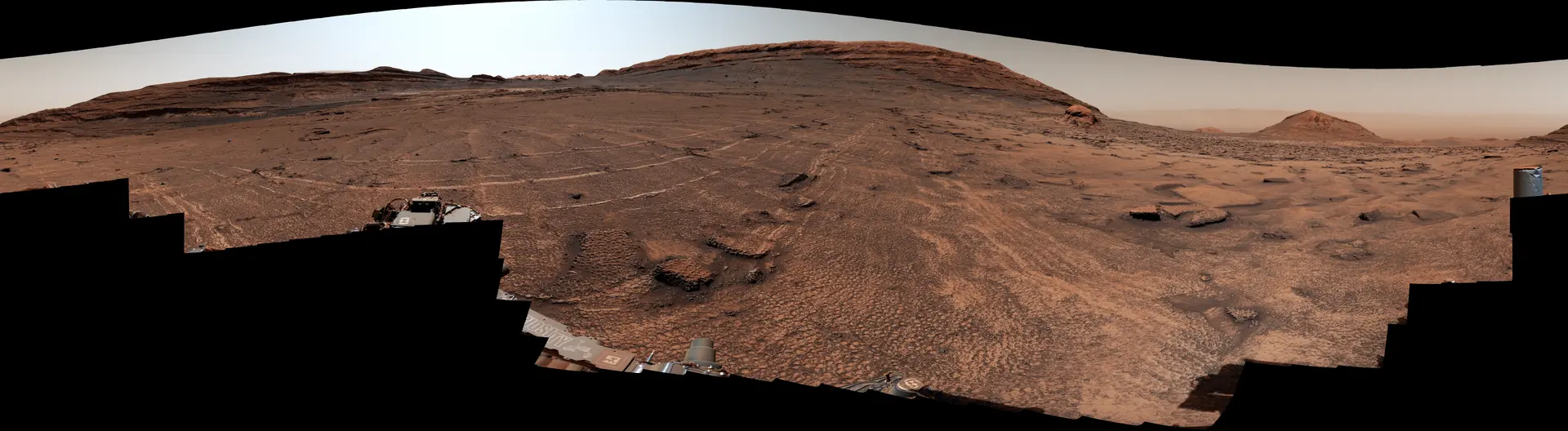
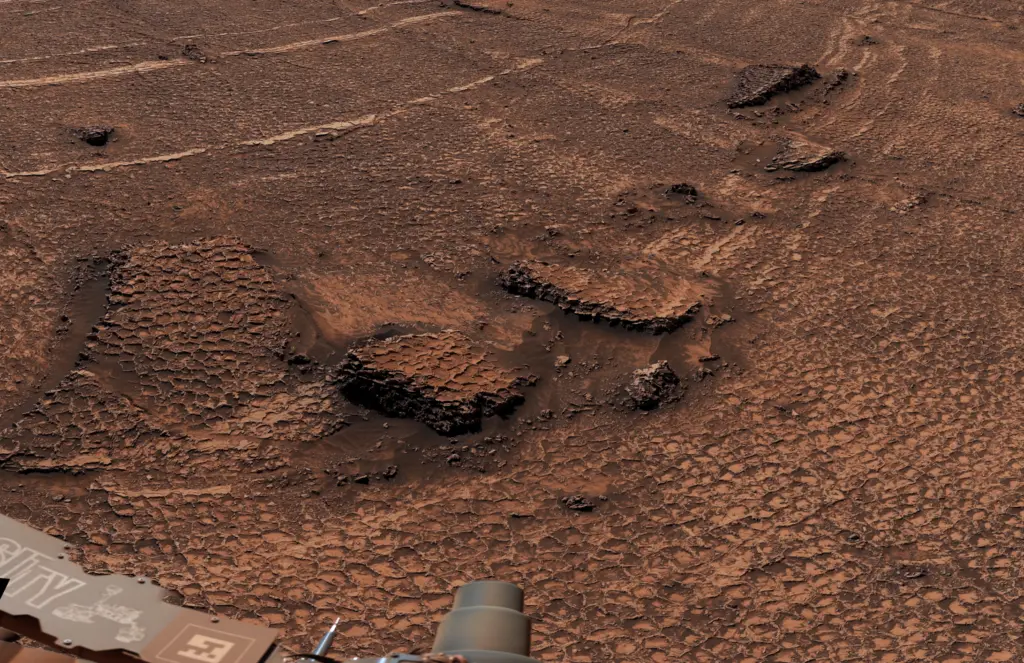
Picture a flat expanse that looks tiled by hand—but every tile is a slightly different shape, and none were laid by anyone. That’s what NASA’s Mars Curiosity rover recently drove into: a broad “sea” of polygon-like patterns etched into the surface, each only a few centimeters across. Mission scientist Ashwin Vasavada put it simply: “We measured their shapes and chemistry carefully,” hoping the data hide clues to how they formed.
It’s a striking scene, but not a singular one. Researchers have documented polygonal features across Mars for years, including from orbit. What makes this moment newsworthy is the ground truth. Curiosity is sitting on top of them, seeing features about 4–8 centimeters (1.5–3 inches) across and sampling them up close. That offers a rare chance to connect texture, setting and composition in one place and time.
Why this is being asked now
Curiosity’s latest images show an unusually extensive field of small polygons, and researchers have hypothesized these particular ones formed as mud cracks. That’s a specific claim about process, not just appearance—and process is what turns a pretty pattern into a climate clue. At the same time, the team stresses that more work is needed to understand their formation. The combination—fresh images, a plausible mechanism, and open questions—makes this a good moment to unpack what Martian polygons are and aren’t saying.
The simple picture: drying mud makes tiles
If you’ve watched a puddle dry into a mosaic, you already have the basic intuition for one way polygons can form. As wet sediment loses water, it shrinks. The top layer can’t contract freely because the lower layer resists, so stress builds until cracks open and link up into a network. The result is a field of irregular polygons.
Where that analogy breaks down: on Mars we’re not watching time‑lapse in a backyard. We’re interpreting an ancient or modern process from frozen-in-place patterns, and multiple processes can make similar shapes. The latest features are hypothesized to be mud cracks, but researchers have also pointed to freeze–thaw cycles or stress from ground deformation as other polygon-makers elsewhere on the planet.
Other ways to draw a polygon
Cold ground can fracture as ice within soil expands and contracts seasonally, pushing open cracks that outline polygons. Likewise, slow stretching or squeezing of the crust can fracture surfaces without any wetting or drying at all. From a rover photo alone, a “polygon” is a plan-view shape, not a verdict on cause.
That’s why on-the-spot measurements matter. Curiosity’s team didn’t just admire the geometry; as Vasavada notes, they measured shapes and chemistry carefully. Chemistry can hint at whether fine-grained sediments once held water, and shape statistics can be compared across hypotheses. Even then, researchers emphasize that more work is needed to lock down the formation process for this new field.
A planet that remembers
Mars preserves surface textures unusually well. Without Earth’s vigorous plate tectonics and abundant flowing water to constantly recycle crust, many landscapes on the Red Planet have remained comparatively undisturbed for billions of years. That makes polygons especially valuable: a cracked surface can be a postcard from deep time rather than last season.
Geologists organize that deep time into broad periods. The Pre‑Noachian, Noachian, and possibly Hesperian collectively span roughly 4.5–3.0 billion years ago. A major boundary within that span—the Noachian–Hesperian transition—occurred about 3.8–3.6 billion years ago. Today’s Mars is in the Amazonian period. Pinning a polygon field to any one of those windows would change what it implies about past environments.
Seeing the big picture from above—and the small from below
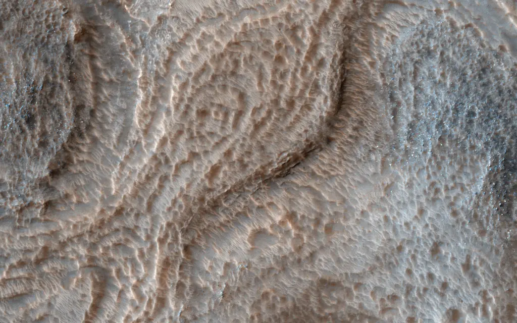
Orbiters have shown that polygonal features occur across Mars. NASA’s High Resolution Imaging Science Experiment (HiRISE) has been photographing the planet since 2006, building a catalog of such patterns spread over plains, crater floors, and more. Those views set the stage; a rover’s close‑in look can then test ideas with geometry and chemistry at hand‑lens scale.
That pairing—global reconnaissance and local scrutiny—is how patterns turn into processes. An orbiter can show where polygons are; a rover can ask what, exactly, the surface is made of at the crack rims, and whether neighboring outcrops record wetting and drying or something colder or more tectonic.
The deeper cut
Equifinality: one shape, many stories
Polygonal crack networks are a classic case of equifinality: distinct processes converging on similar end‑member geometries. In fracture mechanics terms, any process that imposes tensile stress in a quasi‑planar, laterally constrained layer (desiccation shrinkage; volumetric changes from freezing; extensional strain) can nucleate mode I cracks that propagate until stress intensity factors drop below critical. Once multiple cracks advance, tip shielding and attraction steer them toward junctions that minimize elastic energy, yielding familiar mosaics. What breaks the tie among models is not the planform alone but the full context: stratigraphic position; relief at crack edges; infill mineralogy; and spatial statistics of polygon size and vertex valence. A desiccation scenario predicts fine-grained sediments with chemical signatures consistent with past porewaters; seasonal ice-wedge growth predicts evidence of thermal contraction and possible wedge fills; tectonic joints imply orientations tied to regional stress fields. With Curiosity able to pair in situ chemistry with meter‑scale mapping, the analysis can move beyond “it looks like mud cracks” to testing which boundary conditions and material properties actually fit the outcrop.
A giant basin as context, not culprit
Mars hosts colossal basins that shape its geology on a continental scale. Hellas Planitia—about 2,300 kilometers (1,400 miles) across and just over 7,000 meters (23,000 feet) deep below Mars’s zero‑elevation datum—is the largest impact basin on the planet. Features across such terrains provide context for how stress, sedimentation, and climate history played out over vast areas.
That doesn’t mean any given polygon field is caused by a basin. It means that when scientists read surface patterns for environmental clues, they place them on a map that includes mega‑structures like Hellas, long time windows, and present‑day conditions.
What we don’t know—yet
For the newly imaged field, researchers say more work is needed to understand its formation. That includes deciding how strongly to favor the mud‑crack hypothesis over alternatives and, crucially, when the cracking happened relative to Mars’s major geologic periods. The answers depend on integrating Curiosity’s shape and chemistry data with broader mapping from orbit.
Why the answer matters
If these polygons are indeed mud cracks, they speak to cycles of wetting and drying at the surface—an environmental rhythm with implications for how sediments accumulated and changed over time. If they are not, that’s still a result: freeze–thaw or stress‑driven fractures would point to different conditions and timescales. Either way, the pattern is a measurement, not a Rorschach test; interpreted carefully, it narrows what Mars was doing and when.
Sources: Mars Curiosity rover discovers massive field of polygons (phys.org)
Images: Cover: NASA/JPL-Caltech/MSSS / Wikimedia Commons; Figure 1: NASA/JPL-Caltech/MSSS / Wikimedia Commons; Figure 2: NASA/JPL
How this article was made: Everyman Science uses AI tools to structure, format and optimise its articles, and occasionally to produce illustrations where no free photograph exists. The reporting these articles are based on is human-produced and cited above. Spotted an error? Write to [email protected] and we will correct it. — The editors How we work.





Science desk team of Everyman Science, curating and reporting on the day’s most significant developments in research, space exploration, and technology.